Spanish charts had placed Isla Bermeja in the Gulf of Mexico since 1539. The Mexican Navy sailed to the coordinates in September 1997 and found empty sea.
Three years on, Mexico signed a permanent maritime boundary with the United States and used a different island as its northern anchor. The paperwork showing who inside the government knew about the empty water, and when, has never surfaced.
Terminology
- Exclusive Economic Zone (EEZ): A sea area extending 200 nautical miles from a country's coast within which that country alone has the right to fish, drill, and extract resources.
- Continental shelf boundary treaty: A formal agreement between two countries dividing up the underwater land that extends from their coasts, which determines who owns the oil and minerals beneath it.
- Baseline: The official line along a country's coast, or along islands belonging to it, from which the 200-mile sea zone is measured. Move the baseline and the whole zone moves with it.
- The Doughnut Hole (Western Gap): A patch of international water in the middle of the Gulf of Mexico, surrounded on all sides by United States and Mexican sea zones but belonging to neither until divided by treaty.
- Cartographic error: A mistake on a map. In this case, a small island recorded by Spanish sailors in 1539 that turned out never to have been there at all.
The 1978 US-Mexico Maritime Treaty
The 1978 treaty between Mexico and the United States laid down the basic rule. Each country took a 200-nautical-mile Exclusive Economic Zone (EEZ), the sea band where only that coastal state may fish or drill. A patch in the middle of the Gulf sat outside both reaches.
Nobody owned it.
That patch is 17,790 square kilometres of international water surrounded on every side by United States and Mexican sea zones. Diplomats call it the Western Gap. Everyone else calls it the Doughnut Hole.
Mexico’s claim to a slice of that hole depended on which island it picked as its northernmost reference point. Move the anchor, and the 200-mile arc moves with it. The further north the island sat, the further north Mexico’s territorial reach stretched into the gap.
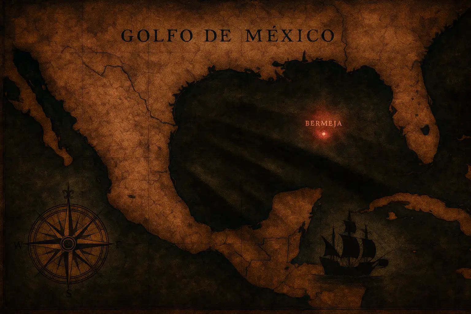
This is where Isla Bermeja entered the calculation. In 1539, the Spanish cartographer Alonso de Santa Cruz recorded the island in El Yucatán e Islas Adyacentes, placing it off the Yucatán Peninsula. A year later, in 1540, Alonso de Chaves added coordinates in Espejo de navegantes and noted the island looked ‘blondish or reddish’, which is where the name Bermeja came from.
That short description in a 1540 navigator’s handbook is the last piece of detailed primary evidence anyone has of Bermeja as a physical place. Every later map simply copied forward from the same sixteenth-century source.
Priority Briefings
New investigations, evidence checks, and unresolved questions from Veriarch, sent directly to your inbox.
Searching for the Disappeared Island
In September 1997, the Secretariat of the Navy (SEMAR) sent an oceanographic expedition to the historical coordinates of Bermeja, 22° 33′ North, 91° 22′ West. SEMAR’s crew covered more than 300 square nautical miles around the spot.
They found open water.
A naval report concluded the island did not exist and recorded the original 1539 entry as a cartographic error. A Spanish research vessel reached the same conclusion in roughly the same window of months. Two independent crews from two countries, working different ships, agreed.
From that point forward, one branch of the Mexican state held physical proof that its northernmost map point was fiction.
But then. A captain’s log is supposed to circulate. It enters fleet command, then SEMAR headquarters, then routes onward to relevant civilian departments. Whoever held that distribution list controlled what the rest of the government got to know.
The list itself is the missing document.
Whether the Secretariat of Foreign Affairs, the Interior Ministry, or the office of President Ernesto Zedillo received a copy in 1997 is not knowable from the public archive. Mexico’s next dated reference to Bermeja appears in a 1998 Interior Ministry registry, which still lists the island as active national territory.
Case Chronology
-
September 1997
SEMAR Expedition
The Secretariat of the Navy (SEMAR) sends an oceanographic expedition to the historical coordinates of Isla Bermeja and finds open water, officially recording the 1539 entry as a cartographic error.
-
April 1998
Boundary Negotiations Open
Formal maritime boundary negotiations begin between the Zedillo and Clinton administrations.
-
1998
Interior Ministry Registry
The Mexican Interior Ministry issues its 1998 registry of national islands, continuing to list Isla Bermeja as active national territory.
-
9 June 2000
Roosevelt Room Signing
The Continental Shelf Boundary Treaty is signed. The Mexican delegation uses the Alacranes Islands as its northernmost reference point instead of Isla Bermeja.
Cartographic Conflict
A year after SEMAR reported open water, Mexico’s Interior Ministry issued its 1998 registry of national islands. Bermeja still sat on the list of active territory. Two ministries inside the same federal government held two opposite facts about the same patch of sea.
Senator José Ángel Conchello opened a public inquiry in 1998 into the missing island and the boundary treaty already in motion. He went further. Conchello accused foreign intelligence agencies of deliberately destroying Bermeja to weaken Mexico’s claim in the Gulf.
The documentary record holds no evidence for that accusation. Conchello named no source and produced no demolition method.
Later in 1998, Conchello died in a car crash. No source in the pack documents a causal link between the inquiry and the crash. Sequence is the only evidence here.
April 1998. Formal boundary negotiations opened between the Zedillo and Clinton administrations. Mexico was still climbing out of the 1995 peso collapse and the United States bailout that followed.
Whatever Mexico’s negotiators carried into those meetings, it was not a corrected map issued by Interior. That registry had not been amended.
1998 Government Baseline Records
| Federal Ministry | Geographic Fact Held |
|---|---|
| Secretariat of the Navy (SEMAR) | Open water (cartographic error confirmed by 1997 expedition) |
| Interior Ministry | Active national territory |
| Secretariat of Foreign Affairs | Under negotiation using inherited maps |
The 2000 Continental Shelf Boundary Treaty
On 9 June 2000, Mexico’s Foreign Secretary Rosario Green and United States Secretary of State Madeleine Albright signed the Continental Shelf Boundary Treaty in the Roosevelt Room of the White House. Presidents Clinton and Zedillo stood behind them.
Under the treaty, Mexico received 10,905 square kilometres of the Doughnut Hole. Washington received 6,562 square kilometres.
Mexico’s delegation had used the Alacranes Islands as its northernmost reference point. Alacranes sits at 22° 23′ North, 89° 40′ West. Bermeja, on the older charts, sat at 22° 33′ North, 91° 22′ West. Their new anchor was both south of and east of the phantom one.
Switching to Alacranes pulled Mexico’s 200-mile arc back from the centre of the gap. Geographers later estimated the abandoned reach was worth roughly 22.5 billion barrels of potential oil. That figure is an estimate of potential extraction, not a measured loss.
Which brings us to the question the routing slip would answer. Mexico’s diplomatic team either knew about the 1997 SEMAR finding and made a quiet call to switch baselines, or they did not know and were working from the same uncorrected Interior Ministry maps.
Mexico’s 2000 ratification debate passed without any public discussion of the baseline switch. No legislator on record raised the change of anchor island.
Which map lay on the table during the Roosevelt Room signing is not in the public record. Whether the Mexican team carried a Bermeja-anchored chart, an Alacranes-anchored chart, or both, is still unaccounted for.
Diplomatic briefing packs prepared for Secretary Green in 2000 remain unread by the public.
Baseline Reference Anchors
| Anchor Location | Coordinates | EEZ Reach Impact |
|---|---|---|
| Isla Bermeja (Historic Chart) | 22° 33' N, 91° 22' W | Northernmost stretch into the Western Gap |
| Alacranes Islands (2000 Treaty) | 22° 23' N, 89° 40' W | Pulled the 200-mile arc back from the centre of the gap |
Uncovering the Truth About Isla Bermeja
Six senators from the National Action Party (PAN) went on the record on 21 October 2008. They wanted an explanation for the island’s disappearance and the terms of the 2000 treaty. Named: Alberto Coppola, Juan Bueno Torio, Felipe Gonzalez, Jaime Rafael Diaz Ochoa.
They gave the executive branch 30 days to explain.
Senator Coppola pointed out that Bermeja had appeared on official cartographic maps produced by the Mexican government in 1991 and again in 1998. The 1998 map post-dated the SEMAR finding by a full year. Coppola wanted to know how an island that the Navy had recorded as fiction had survived in official cartography for that long afterwards.
The senators alleged that President Zedillo had known about the disappearance of Bermeja in 1997, before the boundary negotiations opened. This is an allegation of advance knowledge. The PAN senators presented it as an inference from the publicly known SEMAR finding date, not as direct documentary proof. [Veriarch approached the office of former President Zedillo for comment but received no response.]
No document released to date supports the inference.
Other accounts circulating in 2008 reported that administrative records from the 2000 congressional debate had vanished from state archives. None of the source documents reviewed for this article contained the underlying list of missing files. Veriarch marks the missing-minutes claim as unverified.
Support the Archive
Help fund the retrieval, hosting, and preservation of Veriarch investigations.
2009 Scientific Verification
On 20 March 2009, UNAM launched the research vessel Justo Sierra from the port of Tuxpan, on behalf of the Chamber of Deputies. Her mission was to settle the question with fresh evidence.
She covered more than 10,000 square kilometres of sea. Aerial surveys took nearly 1,000 photographs from altitudes between 400 and 4,000 metres. Ultrasound scans probed to a depth of 472 metres.
Scans found no geological remnants of a sunken landmass. No subsidence, no erosion, no collapsed seamount. Bermeja had never been there to begin with.
In June 2009, Mexico’s Navy ran a secondary expedition aboard the vessel Río Tuxpan. Same conclusion.
Geographically, the question closed cleanly. A 1539 Spanish entry was an error, and the Mexican state carried that error forward as official cartography for 470 years.
Archivally, the question did not close. The 1997 SEMAR distribution list is still unaccounted for, and the public archive contains no record of who inside the Foreign Ministry signed off on the Alacranes baseline.
Source
Sources include: the official 1997 oceanographic expedition report from the Secretariat of the Navy (SEMAR); the 1998 registry of national islands issued by the Mexican Interior Ministry; the ‘Continental Shelf Boundary Treaty’ (2000); official press releases from the U.S. Bureau of Ocean Energy Management; the 2008 public inquiry report from six National Action Party senators compiled via Senado de Mexico InfoSen; ‘The President’s News Conference With President Ernesto Zedillo of Mexico’; archival research stored in the UNM Digital Repository; and the ‘Vanderbilt Journal of Transnational Law’ (2003).
Claim-Source Matrix
| Core Finding | Primary Source Document | Status |
|---|---|---|
| The 1978 US-Mexico EEZ treaty establishes the 200-nautical-mile rule and leaves the Western Gap unresolved. | Vanderbilt Journal of Transnational Law | Confirmed |
| The September 1997 SEMAR oceanographic expedition found open water and recorded Isla Bermeja as a cartographic error. | Isla Bermeja - Wikipedia, la enciclopedia libre | Confirmed |
| The 1998 Interior Ministry official registry lists Isla Bermeja as active national territory. | Panamá América | Confirmed |
| Under the 2000 boundary treaty, Mexico received 10,905 square kilometres of the Doughnut Hole. | Bureau of Ocean Energy Management (BOEM) News Release | Confirmed |
| Underwater scans by the Justo Sierra expedition (2009) down to 472 metres showed no geological remnants of a sunken landmass. | Mexico Claims to Gulf Shrink with Island's Loss | Confirmed |
What we still do not know
- Which civilian departments appeared on the distribution list of the September 1997 SEMAR post-action report, and who inside those departments signed for receipt.
- Whether the Secretariat of Foreign Affairs requested an updated baseline map from the Interior Ministry before the April 1998 negotiation meetings, and which map was returned.
- Where the 2000 congressional ratification minutes now sit, and the identity of the archivist who logged them when they were last accessed.
- How the United States negotiating team handled any internal awareness of the Mexican baseline error during the 1998 to 2000 talks.
- Senator José Ángel Conchello's personal research files from his 1998 inquiry, and the current physical location of those papers.
- The exact map that lay on the table during the Roosevelt Room signing on 9 June 2000.
Comments (0)